 FATMAP - 3D Maps
FATMAP - 3D Maps
無料
Understand the terrain and know any area like a local on day one with outdoor adventure maps from FATMAP. Now introducing both winter and all new summer* maps!
(*All summer maps are in beta)
FATMAP is the ultimate tool kit for skiing, hiking and mountain biking adventures, bringing together expert content and mapping tools in one app.
Recommended minimum requirements:
- 1GB of RAM or more.- Android 4.0 Ice Cream Sandwich or higher
** For technical support, contact: [email protected]
--------------------------
*OVERVIEW*
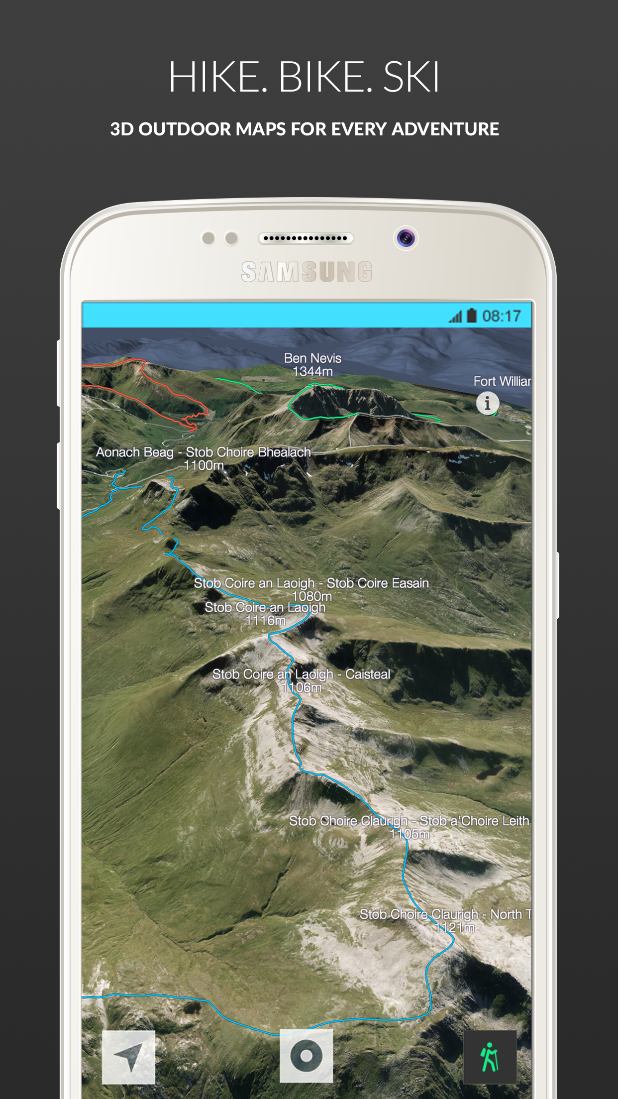
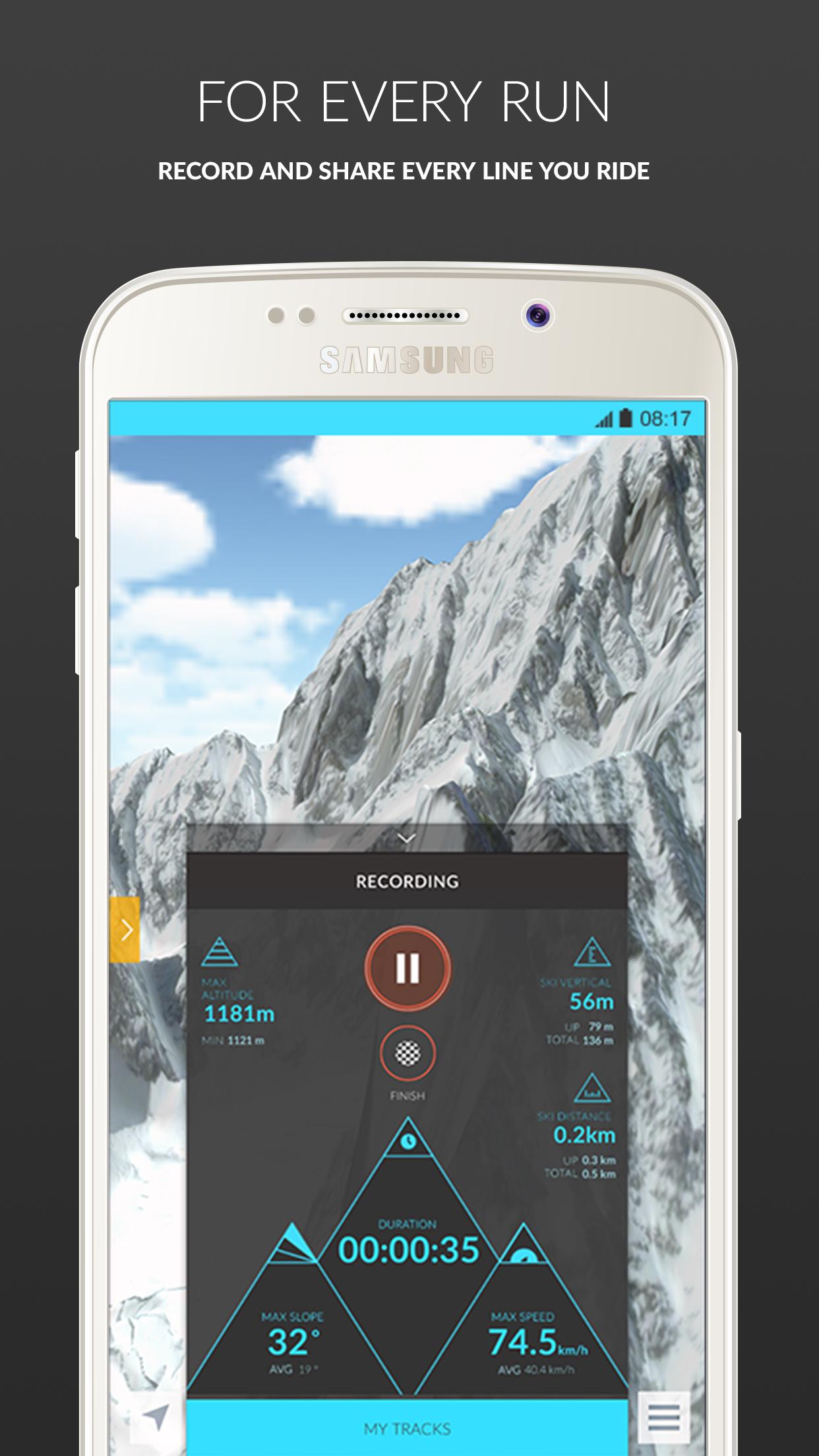
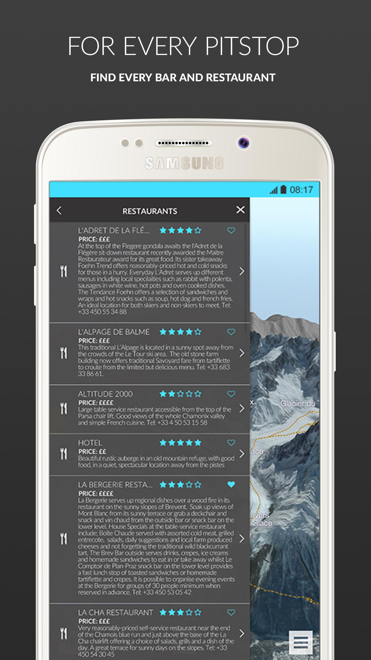
Enjoy highly accurate GPS-enabled ski navigation to locate yourself with ease and experience virtual reality 3D fly-throughs of piste and classic off-piste lines. See every ski line mapped, detailed and rated in ultra high-resolution 3D. Freeriders can tap into our essential terrain intelligence menu to assess risk zones and slope gradients, for a safer day off-piste. Share your stats with built-in ski tracking, access interactive resort information and upload and share community generated condition reports.
Choose between FREE and PREMIUM two-week or one-year subscriptions.
--------------------------
*FEATURES*
FATMAP Free Features:- Ultra High-Resolution 3D Mapping- Virtual 3D Fly-Throughs- Piste, Off-piste, Hike, Ride Mapping & Profiling- Interactive Adventure Information- Tracking & Stats
FATMAP Premium Features:- Ultra high resolution satellite imagery- Advanced Mapping & Profiling- Avalanche Risk Zones- Gradient Heat Mapping- Crevasse Zones- Altitude Segmentation- Aspect Indicators
--------------------------**NEW SUMMER MAPS**
New maps available:- England - Lake District- Scotland - Ben Nevis- Wales - Brecon Beacons
More coming soon:- Scotland - Glen Coe- Switzerland - Verbier- Switzerland - Zermatt- Switzerland - Lenzerheide- Wales - Snowdonia- Andora - Vallnord- Canada – Whistler- France - Chamonix- France - Morzine & Les Gets- Scotland - Torridon- Scotland - Cuillins- Scotland - Cairngorm
See the complete list of areas launching in 2016 at: http://fatmap.com/ski-resort-maps/
--------------------------
We believe that uncertainty stops us from pushing our limits and finding out who we truly are. FATMAP empowers skiers, hikers and mountain bikers with the knowledge and tools to explore further, safely. We’ve worked with pro skiers, Mountain Guides, Mountain Rescue Associations and skiers and snowboarders everywhere to create FATMAP Ski.
Note: FATMAP uses GPS to record tracks. When these features are activated, FATMAP will continue to use GPS even when the app is in the background. Continued use of GPS running in the background can dramatically decrease battery life.
(*All summer maps are in beta)
FATMAP is the ultimate tool kit for skiing, hiking and mountain biking adventures, bringing together expert content and mapping tools in one app.
Recommended minimum requirements:
- 1GB of RAM or more.- Android 4.0 Ice Cream Sandwich or higher
** For technical support, contact: [email protected]
--------------------------
*OVERVIEW*
Enjoy highly accurate GPS-enabled ski navigation to locate yourself with ease and experience virtual reality 3D fly-throughs of piste and classic off-piste lines. See every ski line mapped, detailed and rated in ultra high-resolution 3D. Freeriders can tap into our essential terrain intelligence menu to assess risk zones and slope gradients, for a safer day off-piste. Share your stats with built-in ski tracking, access interactive resort information and upload and share community generated condition reports.
Choose between FREE and PREMIUM two-week or one-year subscriptions.
--------------------------
*FEATURES*
FATMAP Free Features:- Ultra High-Resolution 3D Mapping- Virtual 3D Fly-Throughs- Piste, Off-piste, Hike, Ride Mapping & Profiling- Interactive Adventure Information- Tracking & Stats
FATMAP Premium Features:- Ultra high resolution satellite imagery- Advanced Mapping & Profiling- Avalanche Risk Zones- Gradient Heat Mapping- Crevasse Zones- Altitude Segmentation- Aspect Indicators
--------------------------**NEW SUMMER MAPS**
New maps available:- England - Lake District- Scotland - Ben Nevis- Wales - Brecon Beacons
More coming soon:- Scotland - Glen Coe- Switzerland - Verbier- Switzerland - Zermatt- Switzerland - Lenzerheide- Wales - Snowdonia- Andora - Vallnord- Canada – Whistler- France - Chamonix- France - Morzine & Les Gets- Scotland - Torridon- Scotland - Cuillins- Scotland - Cairngorm
See the complete list of areas launching in 2016 at: http://fatmap.com/ski-resort-maps/
--------------------------
We believe that uncertainty stops us from pushing our limits and finding out who we truly are. FATMAP empowers skiers, hikers and mountain bikers with the knowledge and tools to explore further, safely. We’ve worked with pro skiers, Mountain Guides, Mountain Rescue Associations and skiers and snowboarders everywhere to create FATMAP Ski.
Note: FATMAP uses GPS to record tracks. When these features are activated, FATMAP will continue to use GPS even when the app is in the background. Continued use of GPS running in the background can dramatically decrease battery life.