 FATMAP - 3D Mappe, Pista, GPS
FATMAP - 3D Mappe, Pista, GPS
libero
Comprendere il territorio e conoscere ogni area come un locale sin dal primo giorno con le mappe per le attività all'aperto di FATMAP.Da ora disponibili anche le nuove mappe per l'estate e l'inverno!
FATMAP è il migliore kit di strumenti per lo sci, trekking e per le avventure in bici; ricco di contenuti professionali e strumenti di mappatura in una sola app.
[NOTA] - Requisiti minimi:
- 1GB of RAM or more.- Android 4.0 Ice Cream Sandwich or higher
Questa app non è supportata dalle versioni precedenti
** Per assistenza tecnica, contattare: [email protected]* mappe estive con percorsi per trekking e bici
--------------------------
*FEATURES*
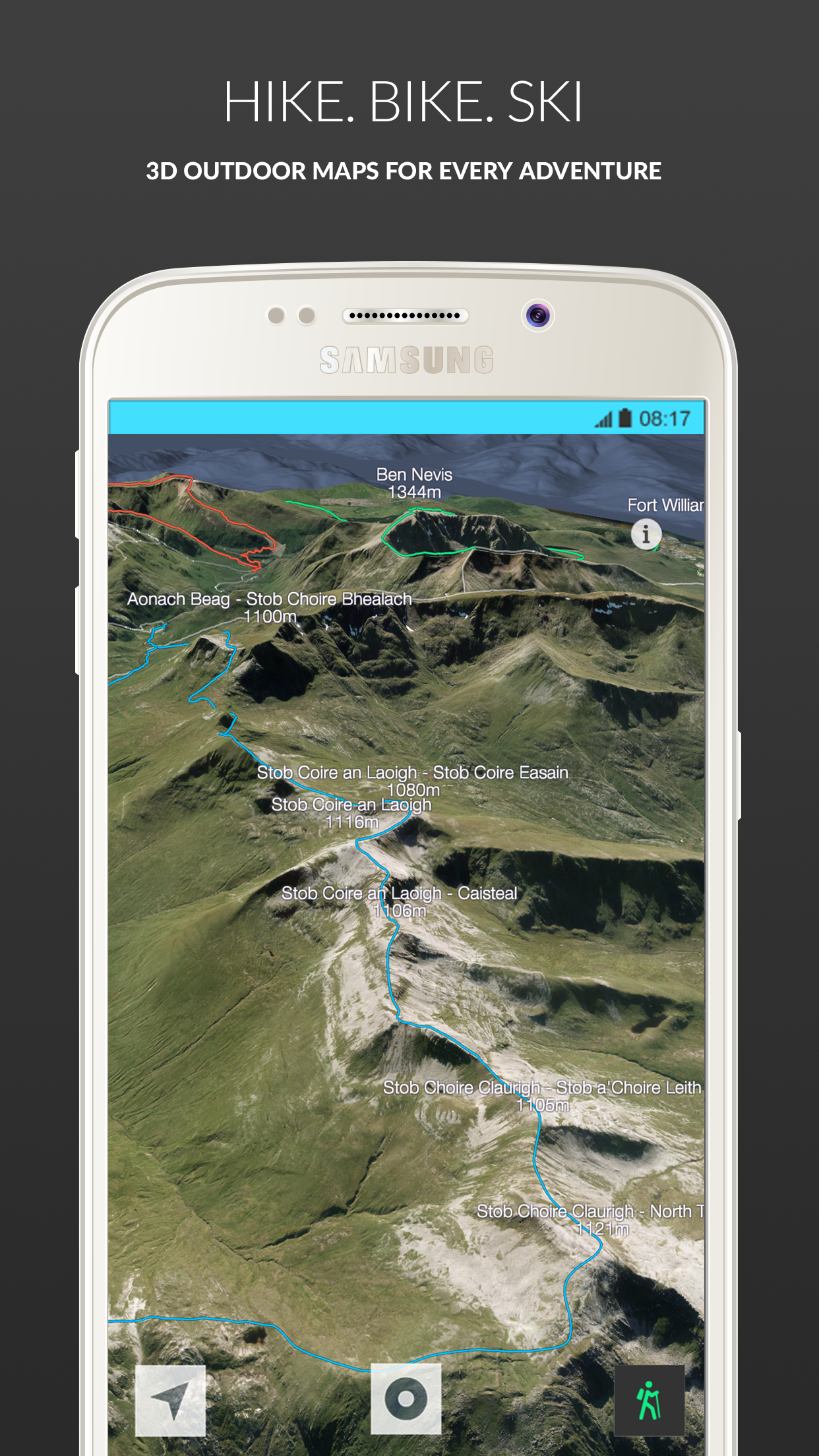
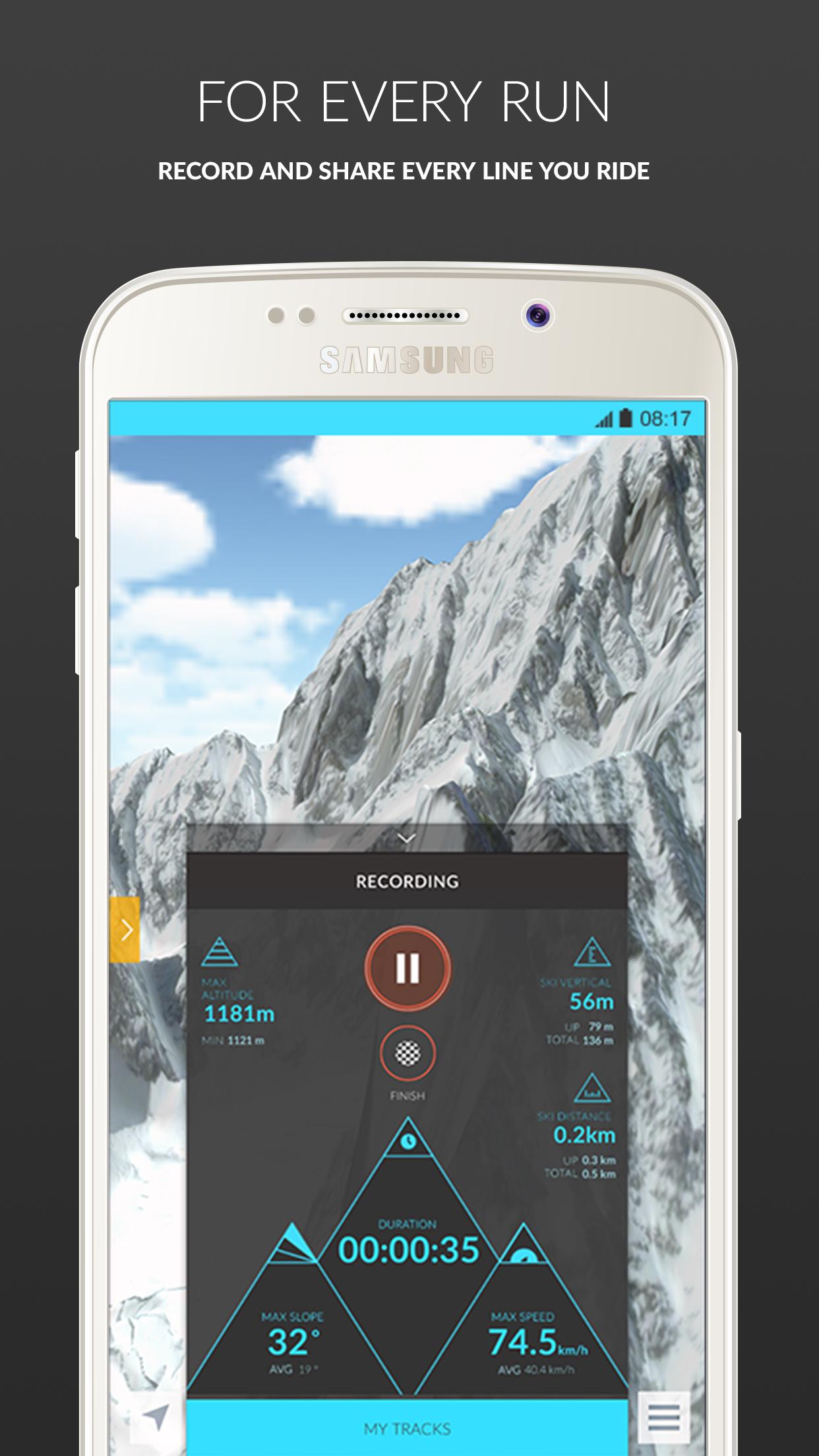
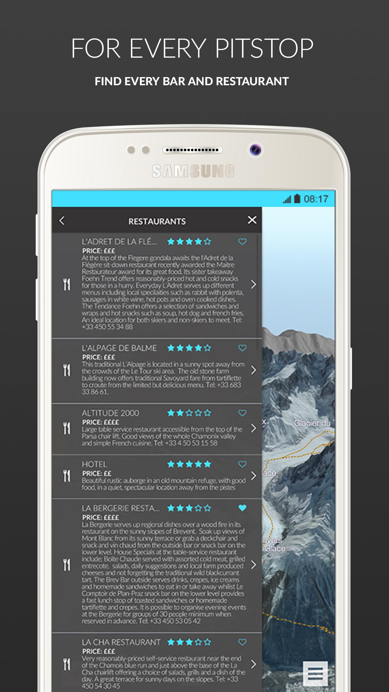
FATMAP Free Features:- Ultra High-Resolution 3D Mapping- Virtual 3D Fly-Throughs- Piste, Off-piste, Hike, Ride Mapping & Profiling- Interactive Adventure Information- Tracking & Stats
FATMAP Premium Features:- Ultra high-resolution satellite imagery- Advanced Mapping & Profiling- Avalanche Risk Zones- Gradient Heat Mapping- Crevasse Zones- Altitude Segmentation- Aspect Indicators
--------------------------**NEW SUMMER MAPS**
New maps available:- England - Lake District- Scotland - Ben Nevis- Wales - Brecon Beacons
More coming soon:- Scotland - Glen Coe- Switzerland - Verbier- Switzerland - Zermatt- Switzerland - Lenzerheide- Wales - Snowdonia- Andora - Vallnord- Canada – Whistler- France - Chamonix- France - Morzine & Les Gets- Scotland - Torridon- Scotland - Cuillins- Scotland - Cairngorm
See the complete list of areas launching in 2016 at: http://fatmap.com/ski-resort-maps/
FATMAP è il migliore kit di strumenti per lo sci, trekking e per le avventure in bici; ricco di contenuti professionali e strumenti di mappatura in una sola app.
[NOTA] - Requisiti minimi:
- 1GB of RAM or more.- Android 4.0 Ice Cream Sandwich or higher
Questa app non è supportata dalle versioni precedenti
** Per assistenza tecnica, contattare: [email protected]* mappe estive con percorsi per trekking e bici
--------------------------
*FEATURES*
FATMAP Free Features:- Ultra High-Resolution 3D Mapping- Virtual 3D Fly-Throughs- Piste, Off-piste, Hike, Ride Mapping & Profiling- Interactive Adventure Information- Tracking & Stats
FATMAP Premium Features:- Ultra high-resolution satellite imagery- Advanced Mapping & Profiling- Avalanche Risk Zones- Gradient Heat Mapping- Crevasse Zones- Altitude Segmentation- Aspect Indicators
--------------------------**NEW SUMMER MAPS**
New maps available:- England - Lake District- Scotland - Ben Nevis- Wales - Brecon Beacons
More coming soon:- Scotland - Glen Coe- Switzerland - Verbier- Switzerland - Zermatt- Switzerland - Lenzerheide- Wales - Snowdonia- Andora - Vallnord- Canada – Whistler- France - Chamonix- France - Morzine & Les Gets- Scotland - Torridon- Scotland - Cuillins- Scotland - Cairngorm
See the complete list of areas launching in 2016 at: http://fatmap.com/ski-resort-maps/